Current conditions
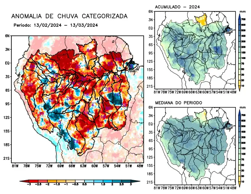
Maps of observed precipitation conditions, individual graphics by basin are produced from MERGE/GPM data generated by INPE/CPTEC, considering the period from de 2000 a 2023. Between February 13 and March 13, 2024, the rainfall pattern remains below climatological levels in almost the entire monitored area, with a precipitation deficit in the hydrographic basins of the Abacaxis, Aripuanã, Branco, Coari, Curuá Una, Guaporé, Içá, Japurá, Javari, Ji-Paraná, Juruá, Juruena, Jutaí, Madeira, Mamoré, Marañon, basins on the left bank of the Amazon in the northeast of the state of Amazonas, the northeast and northwest of the state of Pará, Napo, Negro, Purus, Tapajós, Tefé, Teles Pires, Ucayali, Xingu and the main course of the Solimões River. The Iriri River basin and the main course of the Amazon River in Brazilian and Peruvian territory, alternating areas with positive and negative anomalies, were considered to have observed precipitation close to the climatology for the period. Only the Beni River basin was characterized with positive precipitation anomalies, and the upper Juruá and Purus basins also showed positive precipitation anomalies in recent weeks. The multi-seasonal forecast model indicates a precipitation deficit over a large part of the monitored area, with greater intensity in the east, south and southwest of the region in the coming weeks.