Current conditions
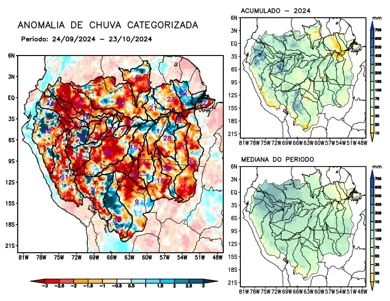
Maps of observed precipitation conditions, individual graphics by basin are produced from MERGE/GPM data generated by INPE/CPTEC, considering the period from de 2000 a 2023. Between September 24 and October 23, 2024, the rainfall pattern remains below climatological levels in a large part of the monitored area, with a precipitation deficit along the course of the Amazon in Peruvian territory, the river basins of the Abacaxis, Aripuanã, Beni, Branco, Coari, Curuá Una, Guaporé, Içá, Iriri, Japurá, Ji-Paraná, Juruá, Juruena, Jutaí, Madeira, basins on the left bank of the Amazon River in the northwest of the state of Pará, Napo, Negro, Purus, Tapajós, Tefé, Teles Pires, Ucayali, Xingu and the main course of the Solimões River, rainfall above climatology characterized the basins located on the left bank of the Amazon River in the northeast of the state of Pará. The multi-model forecast indicates a predominance of rainfall deficits over the east of the monitored region, the east of the state of Amazonas, Roraima and the eastern Amazon in the coming weeks.