Current conditions
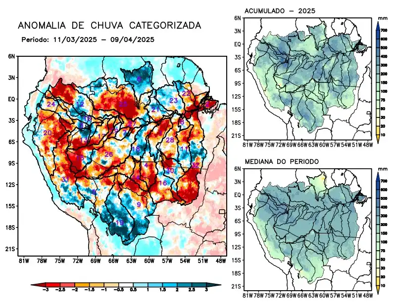
Maps of observed precipitation conditions, individual graphics by basin are produced from MERGE/GPM data generated by INPE/CPTEC, considering the period from de 2000 a 2024. Between March 11 to April 9, 2025, rainfall Rainfall below climatological levels in the monitored area was characterized by a precipitation deficit on the main course of the Amazon River in Brazilian and Peruvian territory, the hydrographic basins of the Abacaxis, Aripuanã, Curuá Una, Japurá, Javari, Ji-Paraná, Juruá, Juruena, Jutaí, Marañon rivers, the left bank of the Amazon River in the northeast of the state of Pará, Negro, Purus, Tapajós, Tefé, Teles Pires, Ucayali, Xingu and the main course of the Solimões River, rainfall above climatology characterized the basins of the Branco and Mamoré rivers, basins on the left bank of the Amazon River in the northwest of the state of Pará. Rainfall behavior close to climatology in the Beni, Coari, Guaporé, Içá, Iriri, Madeira, left bank basins of the Amazon River in the northeast of the state of Amazonas and Napo. The multi-model forecast indicates a predominance of rainfall below climatology in the eastern Amazon, especially in the Branco, Curuá Una, Iriri basins, the basins on the left bank of the Amazon River in the northeast of the state of Amazonas and the northeast and northwest of the states of Pará, Tapajós and Xingu.