Current conditions
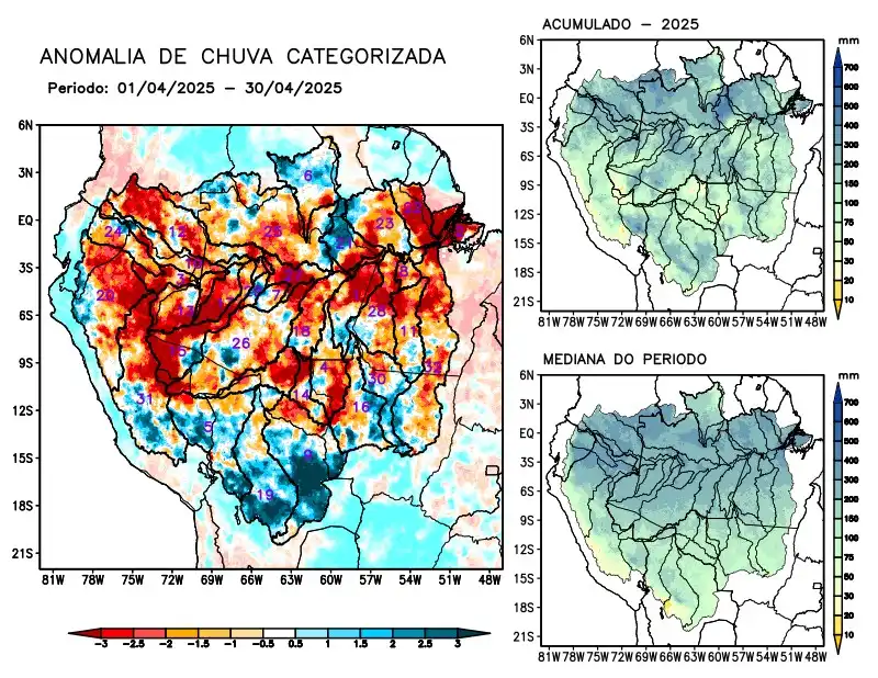
Maps of observed precipitation conditions, individual graphics by basin are produced from MERGE/GPM data generated by INPE/CPTEC, considering the period from de 2000 a 2024. Between April 1 to April 30, 2025, rainfall below climatology in the monitored area was characterized by a precipitation deficit on the main course of the Amazon River in Brazilian and Peruvian territory, the hydrographic basins of the Abacaxis, Aripuanã, Coari, Curuá Una, Içá, Iriri, Japurá, Javari, Ji-Paraná, Juruá, Jutaí, Madeira, Marañon, basins on the left bank of the Amazon River in the northeast and northwest of the state of Pará, Napo, Negro, Purus, Tapajós, Ucayali, Xingu and the main course of the Solimões River, rainfall above climatology characterized the Beni, Guaporé and Mamoré river basins. Rainfall behavior close to climatology over the Branco, Juruena, basins on the left bank of the Amazon River in the northeast of the state of Amazonas, Tefé and Teles Pires. The multimodel forecast indicates a predominance of rainfall below climatology in the center and northeast of the monitored region over the main course of the Amazon River in Brazilian territory and the basins of the Abacaxis, Aripuanã, Coari, Curuá Una, Iriri, Javari, Jutaí, Madeira, basins on the left bank of the Amazon River in the northeast of the state of Amazonas and the northeast and northwest of the states of Pará, Purus, Tapajós, Tefé and Xingu, and rainfall above the climatology forecast in isolated areas over the Branco and Napo river basins.