Current conditions
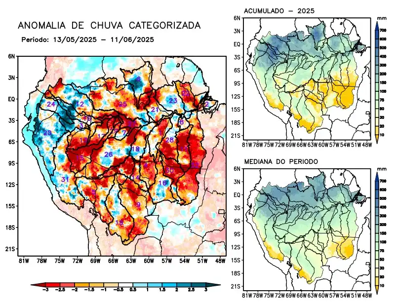
Maps of observed precipitation conditions, individual graphics by basin are produced from MERGE/GPM data generated by INPE/CPTEC, considering the period from de 2000 a 2024. Between May 13 to June 11, 2025, below-average rainfall in the monitored area resulted in a precipitation deficit over the main course of the Amazon River in Brazilian territory, the hydrographic basins of the Abacaxis, Aripuanã, Beni, Coari, Guaporé, Iriri, Japurá, Javari, Ji-Paraná, Juruá, Juruena, Jutaí, Madeira, Mamoré, basins on the left bank of the Amazon River in the northeast of the state of Amazonas and northeast of the state of Pará, Negro, Purus, Tapajós, Tefé, Teles Pires, Xingu, and the main course of the Solimões River. Rainfall within normal ranges characterized the basins of the Branco, Curuá Una, Içá, Ucayali, and the left bank basin of the Amazon River in the northwest of the state of Pará. The multi-model indicates that for the coming weeks, rainfall will be below normal on the main course of the Amazon River in Brazilian territory and the left bank basins of the Amazon River in the northeast and northwest of the state of Pará. above-average rainfall is expected over the main course of the Amazon River in Peruvian territory, the hydrographic basins of the Beni, Guaporé, Içá, Japurá, Javari, Mamoré, Marañon, Napo, Negro, Purus, and Ucayali rivers, and the main course of the Solimões River.