Current conditions
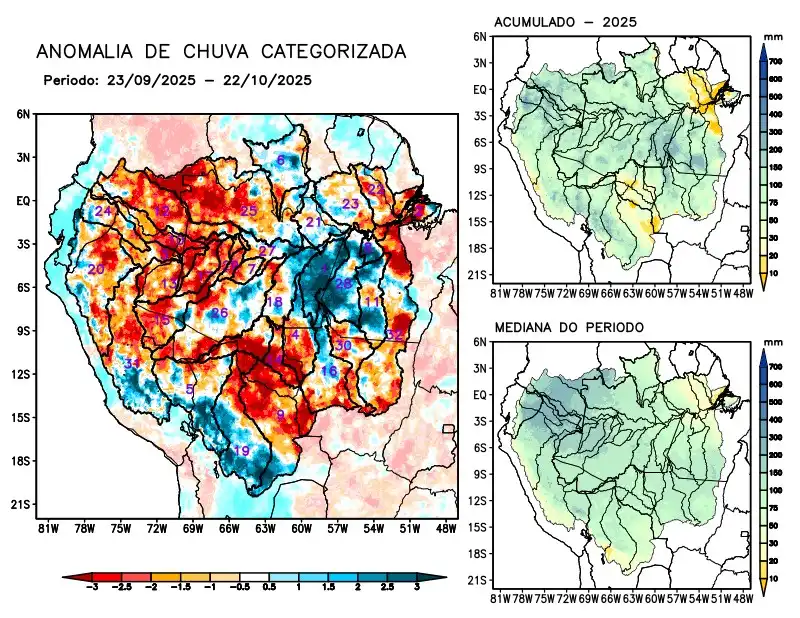
Maps of observed precipitation conditions, individual graphics by basin are produced from MERGE/GPM data generated by INPE/CPTEC, considering the period from de 2000 a 2024. Between September 23 to October 22, 2025, rainfall below climatological norms prevailed over the northwest and southeast of the monitored region, characterized by precipitation deficits over the main course of the Amazon River in Brazilian and Peruvian territories, the hydrographic basins of the Aripuanã, Coari, Guaporé, Içá, Japurá, Javari, Ji-Paraná, Juruá, Jutaí, Madeira, Marañon, the left bank basins of the Amazon River in the northeast of the state of Pará, Napo, Negro, Purus, Tefé, Teles Pires, Xingu, and the main course of the Solimões River; above-average rainfall is forecast for the Abacaxis, Curuá Una, Iriri, and Tapajós river basins; rainfall close to normal in the Beni, Branco, Juruena, and Mamoré river basins, the left bank basins of the Amazon River in the northeast of the state of Amazonas and in the northwest of the states of Pará and Ucayali. The multimodel indicates below-average rainfall for the coming weeks on the main course of the Amazon River in Brazilian territory, the Abacaxis, Aripuanã, Curuá Una, Guaporé, Iriri, Ji-Paraná, Juruena, Madeira, the left bank basins of the Amazon River in the northeast of the state of Amazonas and in the northeast and northwest of the state of Pará, Tapajós, Teles Pires, and Xingu; rainfall above climatology is forecast for the Javari and Jutaí river basins.