Current conditions
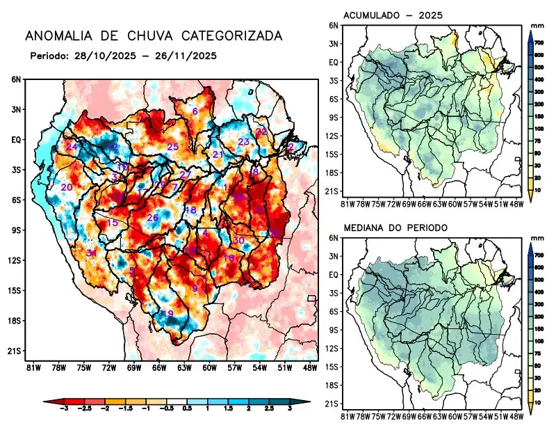
Maps of observed precipitation conditions, individual graphics by basin are produced from MERGE/GPM data generated by INPE/CPTEC, considering the period from de 2000 a 2024. Between October 28 to November 26, 2025, rainfall below climatological norms prevailed over the southeastern part of the monitored region, resulting in precipitation deficits in the watersheds of the Abacaxis, Aripuanã, Beni, Branco, Coari, Curuá Una, Guaporé, Iriri, Javari, Ji-Paraná, Juruá, Juruena, Jutaí, Madeira, Mamoré, basins on the left bank of the Amazon River in the northeast of the state of Pará, Negro, Purus, Tapajós, Tefé, Teles Pires, Ucayali, Xingu, and the main course of the Solimões River. there were no records of rainfall above the climatology in the monitored region; rainfall close to normal on the main course of the Amazon River in Brazilian and Peruvian territories, the Curuá Una, Içá, Japurá, and Marañon river basins, the left bank basins of the Amazon River in the northeast and northwest of the state of Pará, and Napo. The multimodel indicates the following forecast for the coming weeks rainfall above climatological norms on the main course of the Amazon River in Peruvian territory, the Içá, Javari, Napo, Purus, and Tefé river basins; below- climatological rainfall over the main course of the Amazon River in Brazilian territory, the Branco, Curuá Una, Iriri, and Juruena river basins, the left bank basins of the Amazon River in northeastern Pará State, and the Tapajós, Teles Pires, and Xingu rivers.