Current conditions
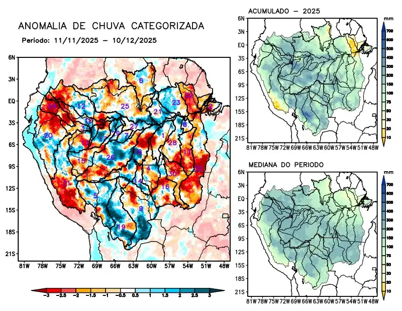
Maps of observed precipitation conditions, individual graphics by basin are produced from MERGE/GPM data generated by INPE/CPTEC, considering the period from de 2000 a 2024. Between November 11 to December 10, 2025, above-average rainfall prevailed in the central region and also in the extreme south of the monitored area, characterized by excessive precipitation in the Beni, Coari, and Mamoré river basins, the left bank basins of the Amazon River in the northeast of the state of Amazonas, and Tefé. Negative precipitation anomalies characterized the main course of the Amazon River in Brazilian and Peruvian territories, the Aripuanã, Branco, Içá, Iriri, Japurá, Javari, Juruena, and Marañon river basins, the left bank basins of the Amazon River in the northeast of the state of Pará, and the Napo, Negro, Tapajós, Teles Pires, Ucayali, and Xingu rivers; rainfall close to normal in the watersheds of the Abacaxis, Curuá Una, Guaporé, Ji-Paraná, Juruá, Jutaí, and Madeira rivers, the left bank watersheds of the Amazon River in the northwest of the state of Pará, the Purus River, and the main course of the Solimões River. The multimodel indicates below-normal rainfall for the coming weeks over almost the entire monitored region, with the exception of the main course of the Amazon River in Peruvian territory and the Jutaí and Marañon river basins, which are expected to have normal rainfall.