Current conditions
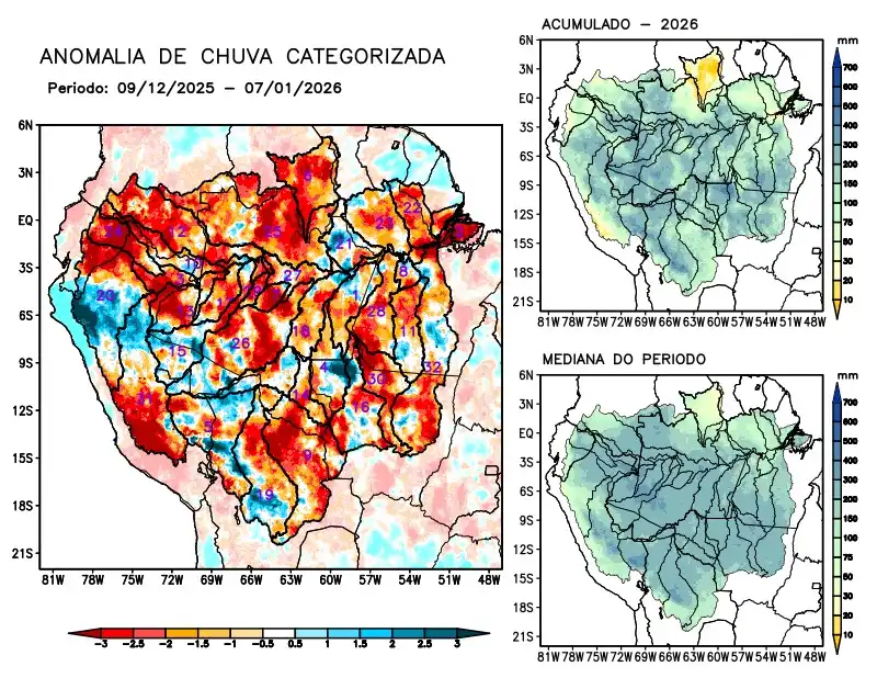
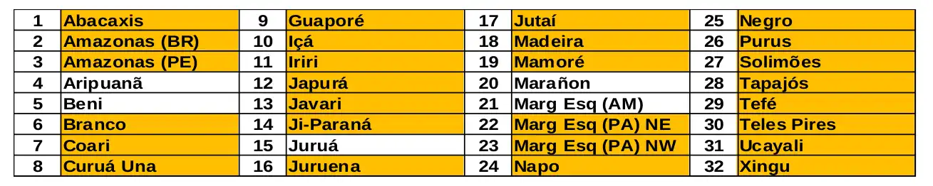
Maps of observed precipitation conditions, individual graphics by basin are produced from MERGE/GPM data generated by INPE/CPTEC, considering the period from de 2000 a 2025. Between December 9 to January 7, 2026, below-average rainfall caused precipitation deficits along the main course of the Amazon River in Brazilian and Peruvian territories, as well as in the watersheds of the Abacaxis, Branco, Coari, Curuá Una, Guaporé, Içá, Iriri, Japurá, Javari, Ji-Paraná, Juruena, Jutaí, Madeira, Mamoré, basins on the left bank of the Amazon River in the northeast and northwest of the state of Pará, Napo, Negro, Purus, Tapajós, Tefé, Teles Pires, Ucayali, Xingu, and the main course of the Solimões River; there was no record of excessive precipitation over the monitored region; rainfall close to normal over the Aripuanã, Beni, Juruá, Marañon river basins and the left bank basins of the Amazon River in the northeast of the state of Amazonas. The multimodel indicates below-average rainfall for the coming weeks in the eastern part of the monitored region, along the main course of the Amazon River in Brazilian territory, and in the Abacaxis, Aripuanã, Curuá Una, Guaporé, Iriri, Ji-Paraná, Juruena, Mamoré, the left bank basins of the Amazon River in the northeast of the state of Amazonas and in the northeast and northwest of the state of Pará, Tapajós, Teles Pires, and Xingu; above-average rainfall forecast in the west of the monitored region, along the main course of the Amazon River in Peruvian territory, the Coari, Içá, Japurá, Javari, Juruá, Jutaí, Marañon, Napo, Negro, Purus, Tefé, and Ucayali river basins, and the main course of the Solimões River.