Current conditions
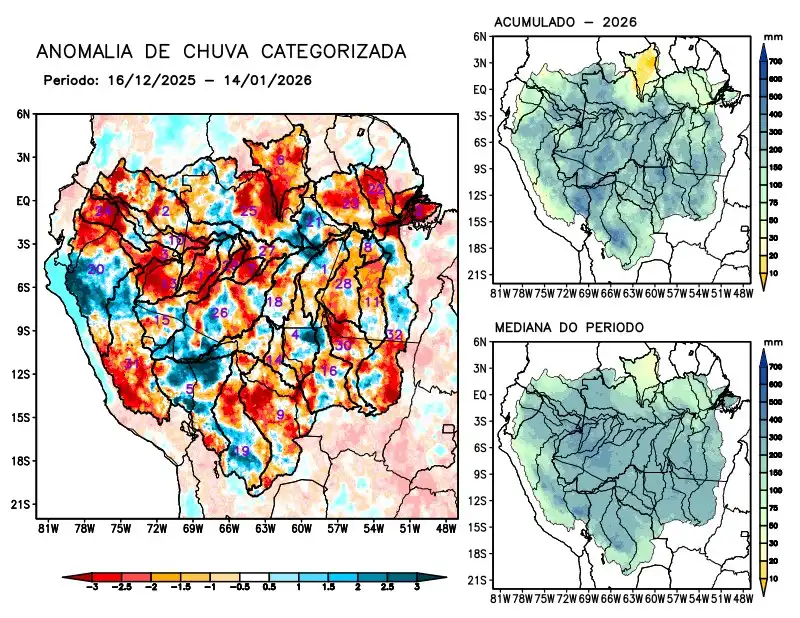
Maps of observed precipitation conditions, individual graphics by basin are produced from MERGE/GPM data generated by INPE/CPTEC, considering the period from de 2000 a 2025. Between December 16 to January 14, 2026, below-average rainfall caused precipitation deficits along the main course of the Amazon River in Brazilian and Peruvian territories, as well as in the watersheds of the Abacaxis, Branco, Coari, Curuá Una, Guaporé, Içá, Iriri, Japurá, Javari, Ji-Paraná, Juruá, Juruena, Jutaí, basins on the left bank of the Amazon River in the northeast and northwest of the state of Pará, Napo, Negro, Tapajós, Tefé, Teles Pires, Ucayali, Xingu, and the main course of the Solimões River; rainfall above climatology recorded over the Beni River basin; rainfall close to normal recorded over the Aripuanã, Madeira, Mamoré, Marañon river basins, basins on the left bank of the Amazon River in the northeast of the state of Amazonas and Purus. The multimodel indicates below-average rainfall for the coming weeks in the east, southeast, and south of the monitored region, on the main course of the Amazon River in Brazilian territory, the Abacaxis, Aripuanã, Beni, Curuá Una, Guaporé, Iriri, Ji- Paraná, Juruena, Mamoré, basins of the left bank of the Amazon River in the northeast of the state of Pará, Tapajós, Teles Pires, and Xingu; rainfall above climatology is forecast for the north and northwest of the monitored region, over the main course of the Amazon River in Peruvian territory, the Branco, Coari, Içá, Japurá, Napo, and Negro river basins, and the main course of the Solimões River.