Single-line diagram of the basins represented
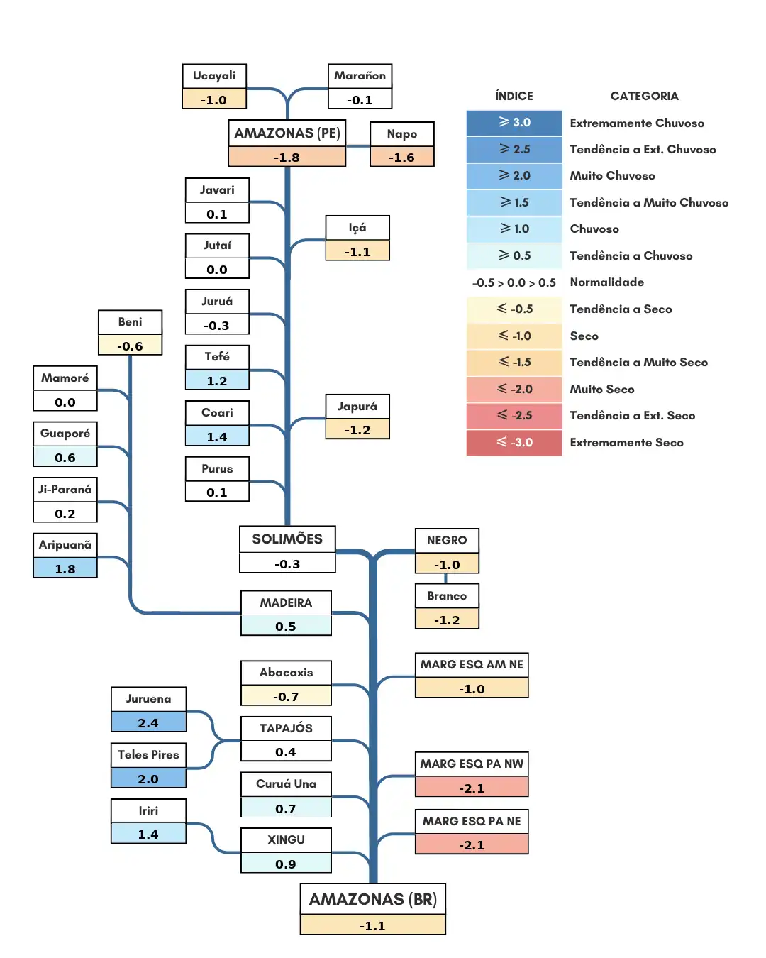
The diagram below shows the distribution and classification of river basins according to precipitation anomaly categories, based on the proposed methodology, for the period from September 23 to July 15, 2026
Analysis of the Single-Line Diagram of the Shown Basins
The analysis of the unifilar diagram shows the distribution and classification of river basins according to the categorization of precipitation anomalies for the period between June 16 to July 15, 2026. In the Andean headwaters (Marañón, Napo, Ucayali, and the main stem of the Amazon), negative precipitation anomalies were concentrated in the Napo River basin and the main stem of the Amazon within Peruvian territory, which were classified as “very dry,” and in the Ucayali River basin, which was classified as “dry.” The Marañón River basin was classified as normal. The main course of the Solimões River and the basins of the Javari, Jutaí, Juruá, and Purus rivers experienced rainfall close to the climatological average for the period. The basins of the Içá and Japurá rivers recorded a precipitation deficit, while the basins of the Tefé and Coari rivers were above the climatological average. The Aripuanã, Madeira, and Guaporé river basins showed positive precipitation anomalies; only the Beni River basin recorded rainfall below the climatological average. Meanwhile, the Ji-Paraná and Mamoré river basins recorded rainfall close to the climatological average. The Branco and Negro river basins recorded precipitation below climatological averages and were classified as experiencing drought conditions. On the left bank of the Amazon River within Brazilian territory, negative precipitation anomalies predominated; the basins in northeastern and northwestern Pará were classified as very dry, and drought conditions were recorded in the northeastern part of the state of Amazonas. On the right bank, the Curuá Una and Xingu river basins were classified as tending toward wet conditions; the Iriri River basin was categorized as wet, while the Juruena and Teles Pires river basins were categorized as very wet. The Tapajós River basin approached normal conditions, while the Abacaxis River basin showed a tendency toward dry conditions. The main course of the Amazon River within Brazilian territory experienced rainfall below the climatological average and was classified as dry.