Current conditions
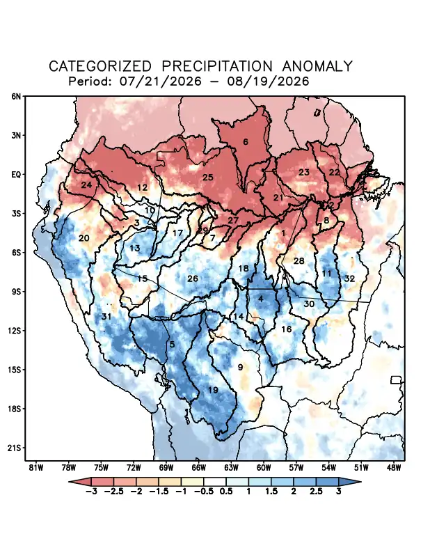
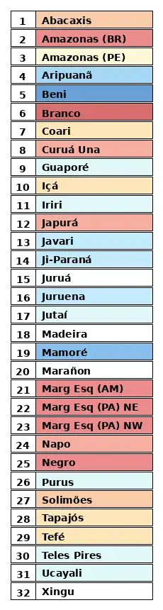
Maps of observed precipitation conditions, individual graphics by basin are produced from MERGE/GPM data generated by INPE/CPTEC, considering the period from de 1998 a 2025. Between July 21 to August 19, 2026, rainfall b below climatological norms resulted in a precipitation deficit along the main course of the Amazon River in Brazilian and Peruvian territory, as well as in the watersheds of the Abacaxis, Branco, and Coari rivers, Curuá Una, Içá, and Japurá rivers; the left-bank basins of the Amazon River in the northeast of the state of Amazonas and the northeast and northwest of the state of Pará; the Napo, Negro, Tapajós, and Tefé river basins; and the main course of the Solimões River; rainfall above climatological averages recorded in the watersheds of the Aripuanã, Beni, Guaporé, Iriri, Javari, Ji-Paraná, Juruena, Jutaí, Mamoré, Purus, Teles Pires, and Ucayali rivers; rainfall close to normal levels recorded in the watersheds of the Juruá, Madeira, Marañon, and Xingu rivers. The multi-model indicates, for the period from August 19 to August 25, 2026, forecast of negative precipitation anomalies concentrated over the north and northeast of the monitored region, along the main course of the Amazon River in Brazilian territory, the Branco and Curuá Una river basins, and the basins on the left bank of the Amazon River in the northeast of the state of Amazonas and the northeast and northwest of the state of Pará; Forecast of positive precipitation anomalies over the Japurá River watershed; forecast of rainfall close to climatological norms (white) for the remaining watersheds.