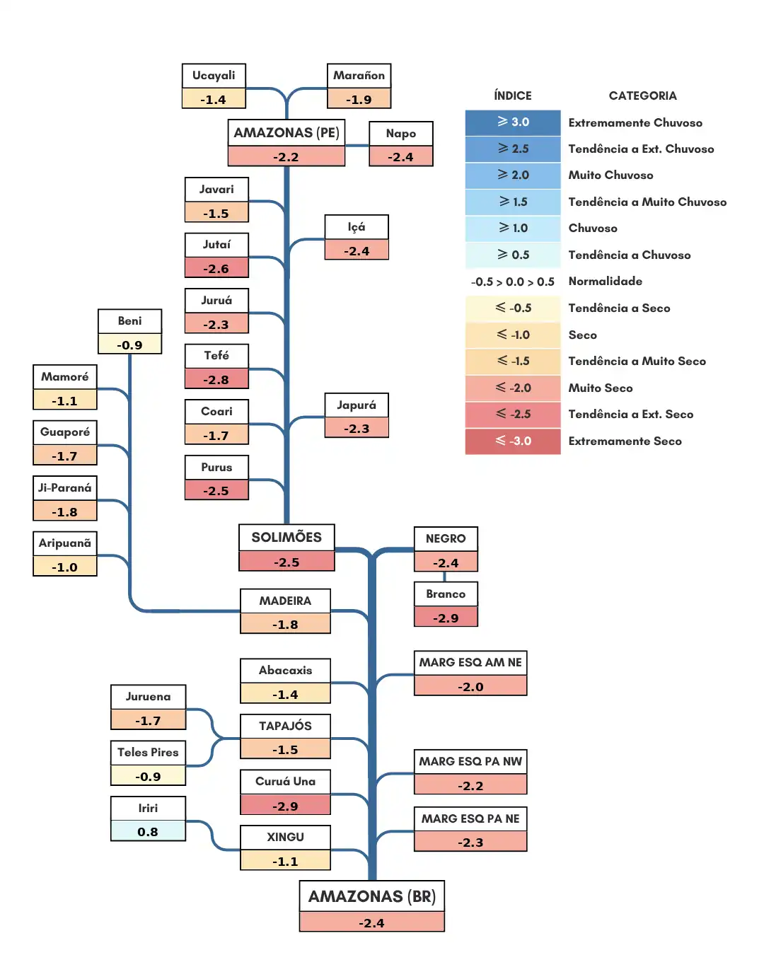
Single-line diagram of the basins represented
The diagram below shows the distribution and classification of river basins according to precipitation anomaly categories, based on the proposed methodology, for the period from October 21 to November 18, 2026
Analysis of the Single-Line Diagram of the Shown Basins
The analysis of the unifilar diagram shows the distribution and classification of river basins according to the categorization of precipitation anomalies for the period between October 20 to November 18, 2026. In the Andean headwaters, rainfall was below normal: the main course of the Amazon River in Peruvian territory and the Napo River basin were in very dry conditions; the Marañon River basin was trending toward very dry conditions; and the Ucayali River basin was in dry conditions. Rainfall below the climatological average characterized the Jutaí, Purus, and Tefé river basins, as well as the main course of the Solimões River, which was trending toward extremely dry conditions; the Içá, Japurá, and Juruá river basins, which were very dry; and the Coari and Javari river basins, which were dry. The Guaporé, Ji-Paraná, and Madeira river basins (tending toward very dry conditions), the Aripuanã and Mamoré basins (dry), and the Beni basin (tending toward dry conditions) exhibited negative precipitation anomalies. The Rio Branco river basin continued to experience strong negative precipitation anomalies and was categorized as tending toward extremely dry conditions. The Rio Negro basin remains in a “tending toward very dry” condition. On the left bank of the Amazon River in Brazilian territory, the continued predominance of negative precipitation anomalies characterized the basins in the northeast of the state of Amazonas and the northeast and northeastern parts of the state of Pará as being in a “very dry” condition. On the right bank, with rainfall below climatological averages: the Curuá Una River basin remains classified as tending toward extremely dry; Juruena and Tapajós (very dry), Abacaxis and Xingu (dry), and Teles Pires (tending toward dry); in contrast, the Iriri River basin was characterized as tending toward wet conditions. The main course of the Amazon River within Brazilian territory continued to experience intensifying negative precipitation anomalies and was categorized as very dry. Negative precipitation anomalies prevail over the Amazon Basin, intensifying drought conditions in the monitored basins. At this time, the drought is spreading from the Andean headwaters—tributaries of the Solimões River—to the Negro and Branco River basins and the Eastern Amazon, under the influence of the established El Niño event in the Pacific Ocean (already classified as “very strong”). Impacts on the region’s hydrological regime have been observed, with major rivers remaining in or intensifying their low-flow phase and reports of extensive areas of wildfires affecting native forest areas; waterways are already showing evidence of exposed sandbars, posing a risk to regional navigation.