Current conditions
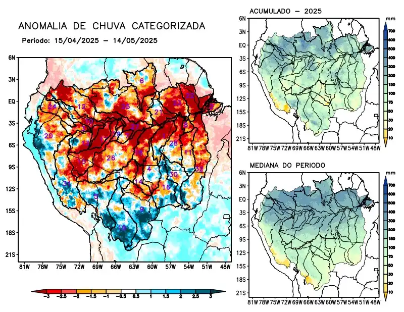
Maps of observed precipitation conditions, individual graphics by basin are produced from MERGE/GPM data generated by INPE/CPTEC, considering the period from de 2000 a 2024. Between April 15 to May 14, 2025, rainfall below climatology in the monitored area was characterized by a precipitation deficit on the main course of the Amazon River in Brazilian and Peruvian territory, the hydrographic basins of the Abacaxis, Aripuanã, Branco, Coari, Curuá Una, Içá, Iriri, Japurá, Javari, Ji-Paraná, Juruá, Jutaí, Madeira, basins on the left bank of the Amazon River in the northeast of the state of Amazonas and the northeast and northwest of the state of Pará, Napo, Negro, Purus, Tapajós, Tefé, Xingu and the main course of the Solimões River, rainfall above climatology characterized the basins of the Beni, Guaporé, Juruena, Mamoré and Teles Pires rivers. Rainfall behavior close to climatology over the Marañon and Ucayali river basins. The multimodel forecast indicates a predominance of rainfall below climatology in the south and tributaries of the right bank of the Amazon River, the basins of the Aripuanã, Beni, Curuá Una, Gauporé, Iriri, Ji-Paraná, Juruena, Mamoré, Tapajós, Teles Pires, Ucayali and Xingu, rainfall above the climatology forecast in the far north and tributaries of the upper and middle Solimões River, on the basins of the Branco, Coari, Içá, Japurá, Javari, Jutaí, Negro, Napo, Tefé and the main course of the Solimões River.